Hello. In this new tutorial we will present the import of buildings from Google Earth to SketchUp.
The main part of this tutorial can be found in this video on our Youtube channel:
We will go to “Window/Components”. Once the component window is open, we will click on the house. Next to it, there is a drop-down arrow. We’ll click on it, and choose “Models Nearby”. We then have all the buildings that are next to the geo-referenced origin.
We will import them one by one. Don’t forget that there are several pages of results. In our example, we have 104 buildings nearby.
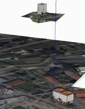
We see a little further on, that a building “flies”.

It has in fact been geo-located to the right height. If we activate the relief, as we saw in the previous tutorial, then we can see that it is referenced to the right height. But we also see that it was imported with a black and white Google Map (SketchUp 7). We then double click to enter the component, select our terrain, right click to “Unlock” as it was locked. Then we delete our plan and activate our relief. We can then unlock the one that is in relief, we delete it and we click outside. This prevents us from duplicating the relief, which is more pleasant.
Please leave your opinion in the comment below.

